

Humanity's Journey Towards Precise Navigation
A look into the past, and the future, of Global Positioning Systems.

A few weeks ago, I found myself giving a talk about improving navigation and GPS systems to a room full of PhDs, industry experts, and government officials in Honolulu. As a junior at Stanford, what place did I have here? And as someone studying computer science, why was I so interested in GPS technology? The answer is simple: our future hinges on ultra-precise positioning.
A world where drones whiz past skyscrapers, self-driving cars dominate roads, and robots autonomously complete tasks, is only possible if every device knows exactly where it is. At first, that sounds easy. But think about the last time you were in the heart of a city — you pulled out your phone and it showed your location as being on the opposite side of the street. Or, worse yet, your phone didn’t pinpoint your location at all. While these might seem like minor annoyances, they can block progress toward fully autonomous vehicles and other ultra-precise applications.
Turns out, this isn’t an easy problem to solve, as shown by the work presented by hundreds of authors annually at conferences held by the Institute of Navigation (ION). On the other hand, even incremental improvements in GPS precision are profound. This idea, that knowing your precise location unlocks incredible technologies, inspired me to join the GPS Lab at Stanford. For the past two years, I’ve presented at ION conferences, where everyone from experts to enthusiasts meet and share ideas about what the future of navigation looks like.
We use GPS, or the Global Positioning System, to navigate our lives. But GPS is more than just a map - it’s the backbone of modern-day society. Yes, it powers our maps, but it also enables our Ubers, DoorDashes, Waymos, and more. It ensures that our flights are safe and secure. It provides precise timing for our phones, cell towers, and stock transactions. In fact, every stock purchase is tagged with a GPS provided ultra-precise timestamp, and our entire global financial system depends on GPS.
Only in recent history have our navigation systems been so precise. And as our systems keep improving, we now have the opportunity to build unimaginable technologies. No matter if you’re interested in Aerospace, Computer Science, Engineering, Policy, Law, or any other discipline, there is a home and opportunity for you in this community. In this article, I talk about:
The evolution of navigation, from ancient techniques to modern GPS technology
What exactly is GPS?
Insights into the future of navigation gained from leading experts and cutting-edge research at the Institute of Navigation conferences
The importance of navigation technology and ways to contribute to this dynamic field
Evolution of Navigation
The earliest navigation methods were celestial, using the sun, moon, stars, and planets. Pioneers invented new technologies like compasses and astrolabes, that let us slowly map more of the world by discovering uncharted territory.
Navigation also heavily relied on dead reckoning, a term that picked up steam recently in popular culture. Dead reckoning estimates your current position by using your direction and distance traveled from your last known position. In Mission Impossible: Dead Reckoning, the director explains that Ethan Hunt (played by Tom Cruise), is forced to pick “a course based solely on [his] last known position,” which becomes a metaphor for Ethan and other major characters in the film. While dead reckoning improved navigation at the time, it was still a highly imprecise method because the errors in estimations would quickly compound over time.

Another way of knowing where you were was by calculating your latitude and longitude. Latitude was an easy problem to solve using celestial bodies and angle measurements. Longitude was much trickier because there were no natural references to measure from, and even our present-day lines are arbitrarily drawn on the globe. Thus, longitude became humanity’s bottleneck to determining accurate positions, and in the 16th and 17th centuries, European governments offered lucrative prizes for anyone who could solve this problem. This challenge led to the founding of the British Royal Observatory, which was later designated the Prime Meridian at 0 degrees longitude.
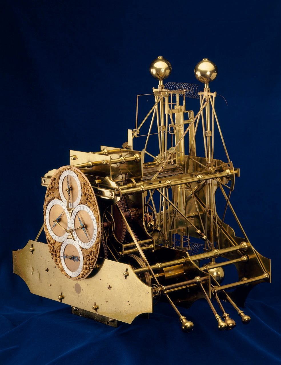
In 1762, carpenter and clockmaker John Harrison finished his three-decade-long quest of developing his solution, the chronometer. The device was an incredibly precise clock, and his insight was that measuring precise timing over the seas and comparing it to a time standard (like GMT) allowed anyone to calculate how far they had traveled. With his innovation, he satisfied the challenge’s requirements, and while the prize was withheld from him because of technicalities, the British Parliament eventually stepped in to award him the prize. His insight foreshadows the way GPS works: precise positioning critically depends on precise timing.
For the next few centuries, more techniques for navigation like the sextant, highly precise clocks, and inertial instruments were developed. Soon, humanity entered the space age.
I was intrigued to find out that GPS wasn’t the first satellite based navigation system. Before the modern system we all know and love, the US Navy had a similar system in 1964: Transit. It was much smaller and meant primarily for submarines. But, because there were only ten satellites and usually only one in view, it would take a full 15 minutes for a location fix. Even worse, these satellites could only provide locations every hour or more.
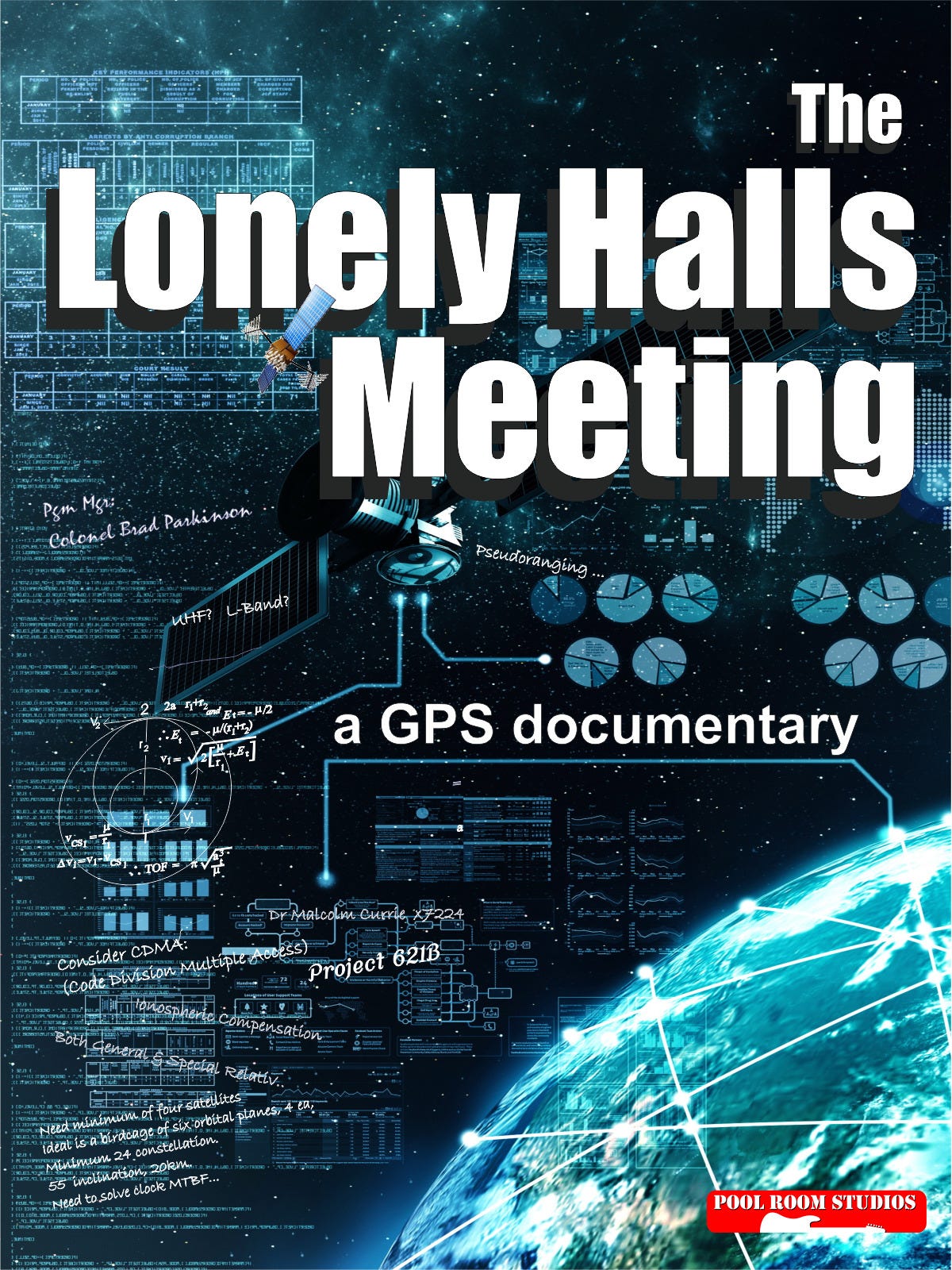
This system was difficult to scale, but the seedlings for GPS were laid. What if we could launch more satellites and provide continuous coverage across the globe? The fathers of GPS, Dr. Bradford Parkinson, Dr. Ivan Getting, and Roger Easton, dreamed of this design and pushed humanity’s capabilities. GPS, as we know it today, was created at the famous Lonely Halls Meeting, in a conference room at the Pentagon in 1973. The first satellite was launched just five years later in 1978. This historic event forever changed the course of humanity, and inspired a documentary that interviews the founders of GPS.
Enter GPS: The Global Positioning System
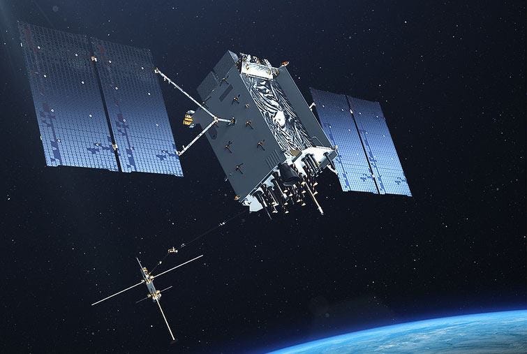
The modern Global Positioning System is a constellation of 30 satellites that supplies the entire globe with precise positioning and is provided by the US Government as a free service.

PNT is the official term for this service - Positioning, Navigation, and Timing. GPS blankets the surface of Earth with the most precise timing currently available, made possible by each satellite’s array of atomic clocks. Precise timing is the magic behind GPS.
GPS satellites’ outgoing signals include the time it was sent and the satellite’s current location. Your receiver, whether that’s a chip inside your phone or a self-driving car, receives this information and compares it to the current time. It then subtracts the two times to calculate the total travel time of the signal. Multiplying the travel time by the speed of the signal gives you the total distance between your receiver and the satellite.

Now, you have the distance to the satellite and know where the satellite is. The next important concept is trilateration, which is how you convert distances from multiple satellites to your final position.
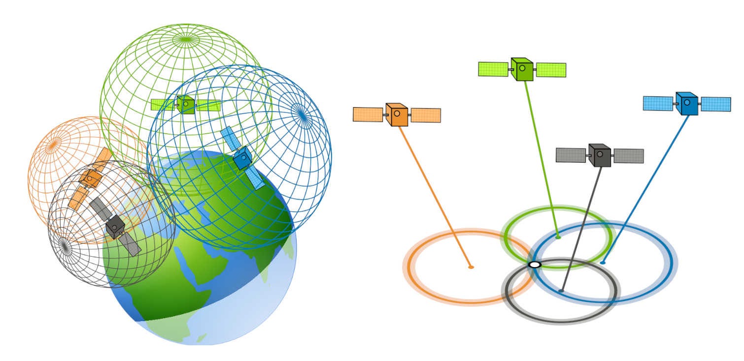
When you have at least 4 GPS satellites in view, you can solve the system of equations for the 4 variables that determine your position: X, Y, Z, and time. Here, time is needed as a separate dimension because the receiver doesn’t have an ultra-precise atomic clock. In these calculations, an error of one nanosecond (or 0.000000001 seconds) roughly results in a one-foot error in your position, so we need a fourth satellite to adjust for the error in the receiver's clock.
In practice, the more GPS satellites you have in view, the better your accuracy. Usually, you can see 8 to 12 satellites in your field of view, and your receiver uses redundancies to reduce the errors from the atmosphere and environment on the signal.
Two of the forefront experts on GPS created an in-depth lecture series explaining how GPS works. Dr. Per Enge was a Stanford Professor, Director of the Stanford GPS Lab, and Co-Founder of the Stanford Center for PNT, and he co-instructed the course with Dr. Frank van Diggelen, who is a Distinguished Engineer at Google, Pioneer in Assisted GNSS, and holds over 100 issued US patents on GNSS. The first lecture is linked below.
Now you understand the basics of how GPS works! GPS enabled huge advancements in our society and pushed the boundaries of navigation. At the Institute of Navigation, the community is proliferating, with more professionals and academics joining the field from a diverse range of interests, all working towards the collaborative effort of improving global navigation.
ION Conferences
Every year, the Institute of Navigation hosts multiple conferences that each focus on a unique aspect of navigation. The most recent conference was Pacific PNT in April, which concentrates on collaboration from Asian countries and is hosted in Honolulu. I spoke with Dr. Sherman Lo, the President of ION, the Program Chair of the Pacific PNT conference, and a lead Stanford GPS Lab researcher, to get his perspectives on ION:
“When I go to ION conferences, I feel I am among friends as there are many people there who I have known, worked and socialized with for many years or decades… One great thing with the culture and size of the group is that you can easily meet and talk to leading researchers and figures in the field.”
From all of my experiences at several ION conferences, this was 100% true. I’ve had the chance to speak with and attend talks from leading experts on navigation, and here are some of the most fascinating things I’ve discovered:
There’s a diverse range of interests in navigation.

No matter what you’re interested in, whether that's university research, industry work, or government services, there’s a place for you in this community:
Tech companies like Apple and Google are interested in improving their location services, maps, and other areas of their tech stack.
At an ION conference, I spoke with Dr. Li-Ta Hsu, a leading researcher at Google and the Hong Kong Polytechnic University, and he mentioned how navigation is critical for both humans and robotics:
“How to reliably provide accurate and precise navigation information becomes one of the bottlenecks for the adaptation of robotics to the human living world. You can learn the latest ideas on navigation technologies and exchange with world navigation experts at ION.”
Universities like Stanford, CU Boulder, Ohio State University, and many others are at the forefront of navigation technologies.
Government Agencies like the Department of Transportation, Space Force, and Coast Guard focus on improving navigation and GPS integrity
Hardware companies like Safran, Spirent, and Trimble are interested in improving the antenna, receiver, and simulator components that drive these systems.
Space and satellite companies like Lockheed Martin Space (which currently builds the GPS satellites) and Xona Space Systems (which focuses on augmenting GPS with LEO, or Low Earth Orbit satellites), are developing the future of space infrastructure and innovative space solutions.
I talked with Dr. Mark Crews, the PNT Advanced Programs Manager and Lockheed Martin Fellow overseeing the future of GPS, and he discussed the many ways the US is planning on improving future GPS satellites, including integrating crosslinks between satellites:
“While awaiting launch, the tenth GPS III is being modified to include an Optical Crosslink Demonstration with work expected to complete by May 31, 2025. As Lockheed Martin produces at least 10 more GPS IIIF Space Vehicles (SV11-20), the US Space Force is now studying how to effectively integrate Optical Crosslinks to improve signal accuracy and enhance constellation command and control.”
Agriculture companies like John Deere are interested in improving their ultra-precise farming equipment.
Startups like Infleqtion, a quantum company, are focused on building quantum hardware for precise timing and other innovative technologies.
There are quite a few unsolved problems with navigation.
GPS still has some vulnerabilities that many are working on solving:
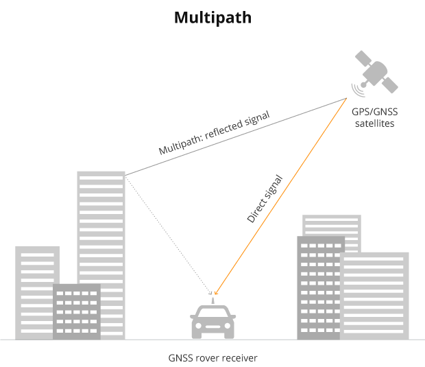
Multipath. In dense urban environments and cities, GPS signals bounce off surfaces like tall buildings before they get to your receiver, which increases the time it takes for your receiver to get the signal and often throws off your location estimates.
Pro tip: If you ever drive into a city, mount your phone to the car using a sturdy phone holder. Your phone will recognize that it's traveling steadily relative to the car, and will use its own inertial system to improve your location accuracy.
GPS Jamming. Using signals that are stronger than those of GPS satellites can disrupt and take down the service in an area. In 2009, a trucker in New Jersey used an illegal GPS jammer to hide his location from his employer, but his device temporarily shut down Newark Airport.
GPS Spoofing. Sending out fake signals can trick the receiver into thinking it’s in a different location, which could have disastrous safety of life consequences.
There’s more than just GPS
For a while, GPS was the only Global Navigation Satellite System, also referred to as GNSS. Today, there are four core GNSS constellations: GPS first launched by the United States in 1978, Glonass first launched by Russia in 1982, BeiDou first launched by China in 2000, and Galileo first launched by the European Union in 2011.
There are even more augmentation systems that improve the core GNSS constellations. The Wide Area Augmentation System (WAAS) was developed by the Federal Aviation Administration (FAA) to augment GPS in the United States to help land planes safely. You’ve likely been on a flight that used this technology.

I spoke with Dr. Todd Walter, one of the leading figures and developers of WAAS, the Director of the Stanford GPS Lab, and past President of ION. Dr. Walter worked directly under Dr. Bradford Parkinson, who envisioned that GPS could be used to land airplanes. After spearheading the nationwide prototype and FAA certification of WAAS, Dr. Walter helped the system become operational in 2003.
“The advantage of [WAAS] is that it can cover all of North America and requires no local installation at the airports... and today services more than 5000 runway ends in the U.S. and Canada.”
Get Involved
At Stanford, I study Computer Science on the Artificial Intelligence track, but I’m also minoring in Aerospace Engineering. I wasn’t always interested in space, but during my sophomore year at Stanford, I took Dr. Andrew Barrows’s Introductory Seminar, AA 121Q: It IS Rocket Science! Since then, I’ve been fascinated by opportunities in space technologies, and specifically how improving navigation can change the world.
I was inspired to join the Stanford GPS Lab, the leading research organization in the field of navigation. The lab was founded by Dr. Bradford Parkinson, the “father of GPS,” and the lab’s research continues to push the cutting edge of navigation. My research focuses on augmenting GPS with Low Earth Orbit (LEO) satellites, and I hope these contributions one day help us achieve the ultra-precise navigation that will open countless new opportunities.
I spoke with Dr. Sam Pullen, one of my PIs and a lead researcher at the GPS Lab, about his thoughts on what the future of navigation looks like. His answer was truly insightful:
“Over the years, I have seen one of the maxims of Stanford’s Aero/Astro department confirmed again and again: “One thing leads to another.” Each significant innovation in GNSS has spawned new applications and enhanced existing ones, creating a self-sustaining cycle of progress. As a result, GNSS has become a vital pillar of the modern world. I invite those of you who read this to join us and keep this virtuous cycle going for the good of humankind.”
No matter your field, there are many opportunities in the realm of navigation. Countless technologies use or leverage navigation concepts, and advancements in this area will have far-reaching impacts across many industries. Join us in this exciting journey toward a future where ultra-precise navigation transforms the way we live and work.
Thank you for letting me share about the amazing world of navigation! Feel free to reach out to me at sukrut@stanford.edu if you have any questions or want to talk about all things GPS and navigation!
— Sukrut Oak
 | A guest post by
|